Skip to content
Submit
Close search
INSTRUMENTS/GNSS
expand
collapse
INSTRUMENTS/GNSS
GPS
Robotic Total Stations
Topcon 3D Scanners
Total Stations
Data Controllers
Lasers, Levels, Theodolites
MACHINE CONTROL
expand
collapse
MACHINE CONTROL
Machine Control
SLAM/HANDHELD LIDAR SCANNERS
expand
collapse
SLAM/HANDHELD LIDAR SCANNERS
SLAM/HANDHELD LIDAR SCANNERS
DRONES NDAA
expand
collapse
DRONES NDAA
Inspired Flight
Freefly
WISPR Systems
DRONES STANDARD
expand
collapse
DRONES STANDARD
CHCNAV
UAV LIDAR NDAA
expand
collapse
UAV LIDAR NDAA
UAV LIDAR NDAA
UAV LIDAR STANDARD
expand
collapse
UAV LIDAR STANDARD
UAV LIDAR STANDARD
MARINE SYSTEMS
expand
collapse
MARINE SYSTEMS
Marine Systems
PRE-OWNED INSTRUMENTS
expand
collapse
PRE-OWNED INSTRUMENTS
Pre-Owned GPS
Pre-Owned Robotic Total Stations
Pre-Owned Conventional Total Stations
Pre-Owned Drones
SOFTWARE
expand
collapse
SOFTWARE
Surveying
Construction and BIM
3D Scanning
UAV Systems
SUPPLIES & ACCESSORIES
SERVICE
expand
collapse
SERVICE
Training
Repair
iNET
ABOUT US
CONTACT US
expand
collapse
CONTACT US
Contact Us
Birmingham, AL · Jackson, MS · Nashville, TN · Greenville, SC
Submit
Search
Log in
Cart
Cart
expand/collapse
INSTRUMENTS/GNSS
expand
GPS
Robotic Total Stations
Topcon 3D Scanners
Total Stations
Data Controllers
Lasers, Levels, Theodolites
MACHINE CONTROL
expand
Machine Control
SLAM/HANDHELD LIDAR SCANNERS
expand
SLAM/HANDHELD LIDAR SCANNERS
DRONES NDAA
expand
Inspired Flight
Freefly
WISPR Systems
DRONES STANDARD
expand
CHCNAV
UAV LIDAR NDAA
expand
UAV LIDAR NDAA
UAV LIDAR STANDARD
expand
UAV LIDAR STANDARD
MARINE SYSTEMS
expand
Marine Systems
PRE-OWNED INSTRUMENTS
expand
Pre-Owned GPS
Pre-Owned Robotic Total Stations
Pre-Owned Conventional Total Stations
Pre-Owned Drones
SOFTWARE
expand
Surveying
Construction and BIM
3D Scanning
UAV Systems
SUPPLIES & ACCESSORIES
SERVICE
expand
Training
Repair
iNET
ABOUT US
CONTACT US
expand
Contact Us
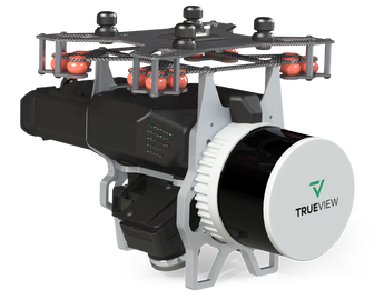
GeoCue TV 535
Call for pricing
Schedule a call/Virtual Demo