GeoCue TrueView 720
Call for pricing
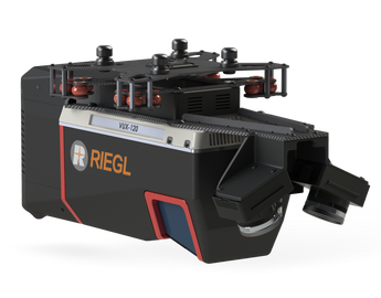
A New Class of System for New Challenges: TrueView 720 with 3 LiDAR + imagery sensors
TrueView 720 is our fourth generation RIEGL integration. This is the system for high point density corridor mapping. Using the RIEGL VUX-120 with 3 lidar scanners (oriented nadir and +10 degrees forward and -10 degrees backward) and 3 oblique/nadir cameras for extremely detailed data collection in one flight path. When scanning power lines, users will be able to capture the poles vertically, front and back. The system can be integrated with drones, airplanes, or helicopters. Ask about custom camera configurations to cover your specific needs.
LiDAR Sensor
• Sensor: RIEGL VUX-120
• 1550 nm Class 1 eye safe
• Range: Max 1400m, and typical 200m at FULL PRR 2400kHz
20% reflectivity.
• Accuracy: 10mm and Precision 5mm typical 1sigma
• Number of Lasers: 3 channels spread over 20° (-10, 0, 10)
• Total Pulse Rate: 2400kHz, with up to 2,000,000 measurements
per second
• Rotation Speeds: 50-400Hz
• Beam Spot Size:
• At 100m: 40mm
• Returns: 5 at 2400kHz, up to 32 at lower PRR/Higher range
Platform
• Size:
• Length: 412 mm
• Width: 185 mm
• Height: 187 mm
• Weight:
• 3.4 kg for payload
• 3.65 kg for payload with
accessories
• Power Consumption: 78.1 W typical,
91 peak
Applications
• Densely Vegetated Topography
• Stock Pile Volumetric Calculation
• Vertical Structures
• Wire Extraction - Distribution
• Vegetation Encroachment
System
• Control: WIFI + button control
• Storage:
• 128Gb internal storage + 32GB exterbal storage for
Trajectory and pictures
• 2TB internal storagefor Laser Data, 480GB USB for
Cfast card
Navigation Solution
• INS: Trimble Applanix APX20
• Post-Processing Options:
• Single Base
• PP-RTX (no base station) with fast convergence
• SmartBase
• Performance (PPK):
• 0.03-0.05 RMSE
• Better than 0.035° heading, 0.015 pitch & roll
Cameras
• Type: 3 * 20 MP Sony mechanical leaf shutter, calibrated
• Motion Blur: 0.37 pixel @5 m/s @ 80 m
• FOV: 113° FOV configuration
Processing Modules
• LP360 Drone
(included modules)
• Strip Adjustment
• Photo
• 3D Accuracy
• Optional Add On’s
• Business Intelligence
• Unlimited Project
• Metashape Console
