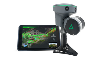
GeoCue TrueView Go
Call for pricing
The TrueView GO 116S Easily Captures Reality With Every Step You Take
Introducing the TrueView GO 116S by GeoCue, a handheld mapping system for seamless indoor and outdoor reality capture and high-definition 3D mapping. This state-of-the-art device features 16 channels, three 5MP high-resolution RGB cameras, and a sophisticated 3D LiDAR & Imagery scanner, easily converting complex environments into precise digital twins.
The TrueView GO 116S offers intuitive operation with a “Ready, Set, GO!” approach. Simply start walking and scan your surrounding environment. Ideal for applications in surveying, construction, and Building Information Models (BIM), this advanced system guarantees fast, easy, and accurate scans every time. Enhance your mapping capabilities with the TrueView GO 116S for unparalleled ease of use and efficiency.
| Data Collection | LiDAR, Imagery, and SLAM |
| LiDAR Scanner | Survey Grade, Class 1, Eye Safe laser @ 905 nm |
| LiDAR Range | 0.05 to 120 m |
| LiDAR Range – Usable | 80 m @ 10% Reflectivity (channels 5 to 12) 50 m @ 10% (channels 1 to 4, 13 to 16) |
| LiDAR Beams/Returns | 16/2 |
| LiDAR FOV (Horizontal) | 270° |
| LiDAR FOV (Vertical) | (30°) (-15° to +15°) |
| Pulse Repetition Rate | 320 Khz |
| System Performance | Absolute accuracy:
Relative accuracy:
|
| Camera Sensor | Three 5 MP cameras (15 MP) |
| Camera FOV | 210° × 170° |
| System Operation Temperature Range | -20° to 50° C |
| Mass | 1.9 kg (including RTK and battery) |
| Power Supply Mode | Lithium battery, supports hot-swapping and portable charger |
| Working Time from a Single Battery | 1 hr |
| Data Storage | 512 GB |
| Field of View | 360° x 270° |
| Loop-free Data Acquisition | Yes |
| Real-time Accuracy Assessment | Yes |
